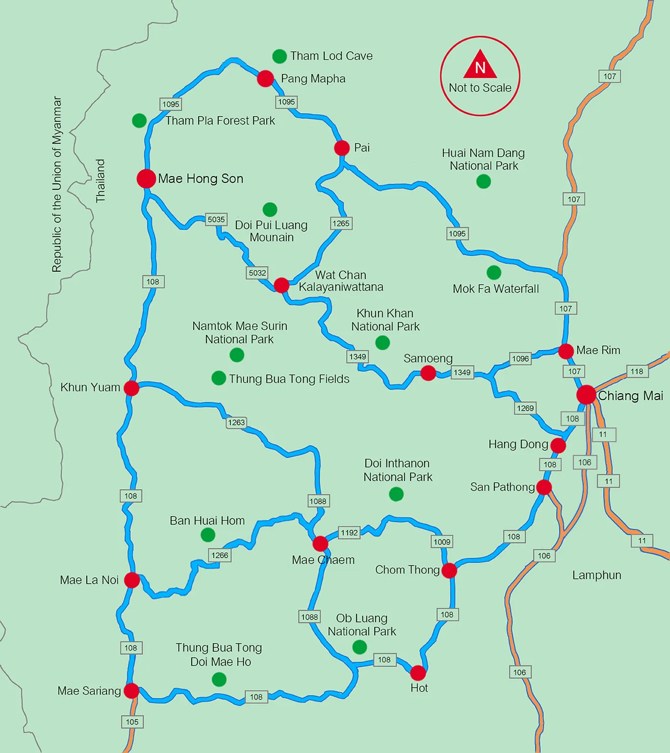
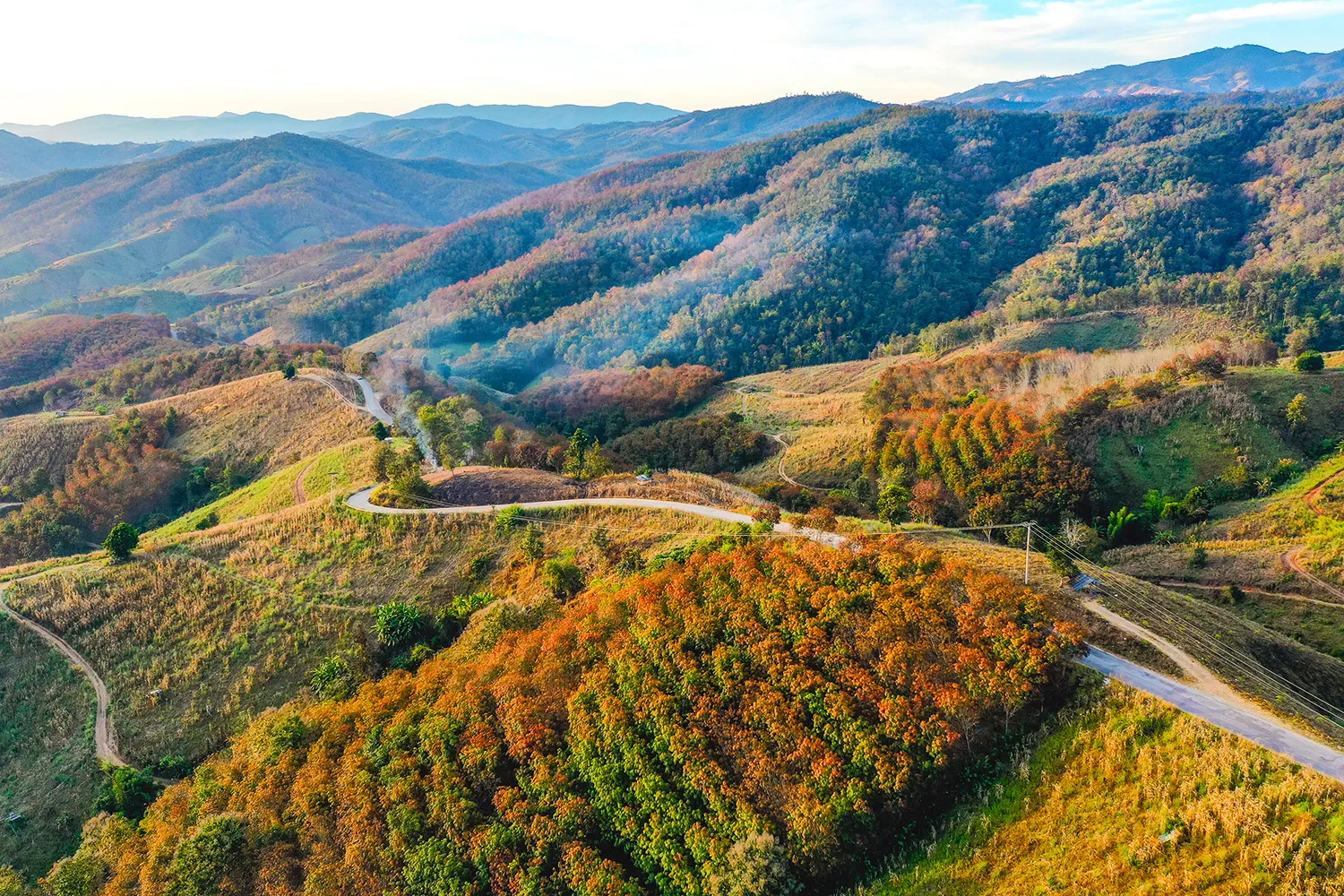
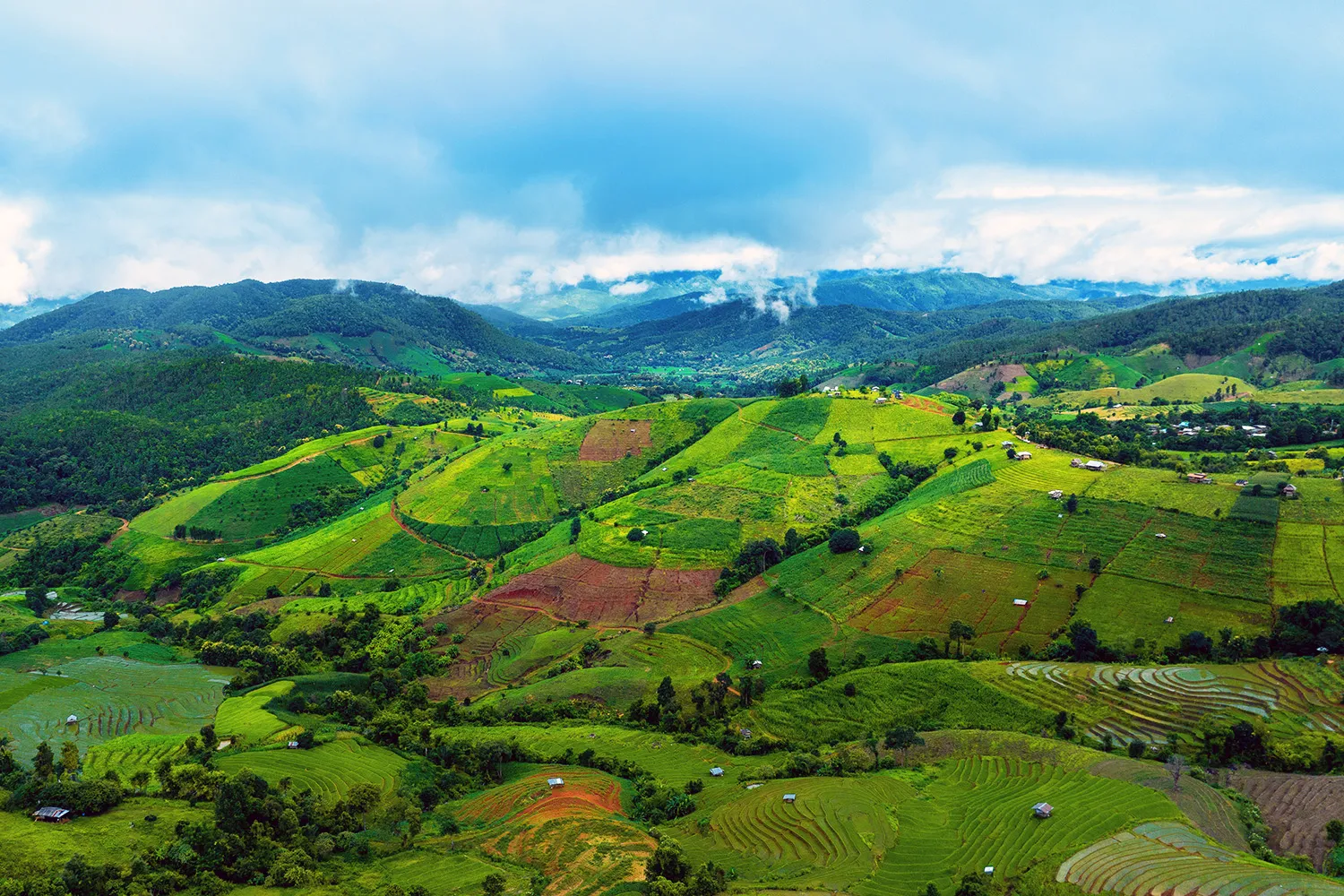
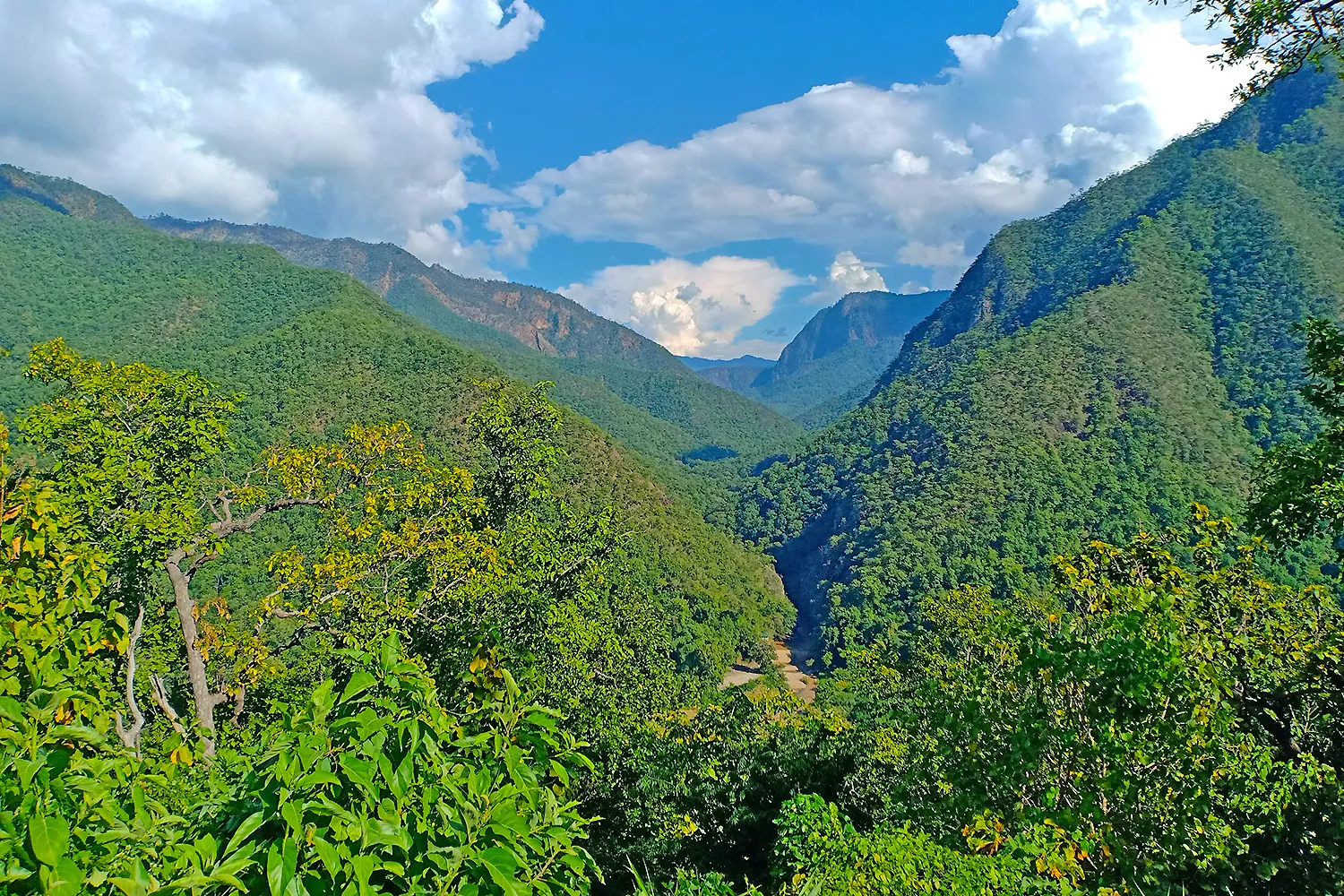
For adventurous tourists who revel in the thrill of driving, Mae Hong Son province boasts scenic driving routes that rank among the most famous in Thailand—an enticing challenge that beckons those seeking convenience and privacy. These breathtaking routes meander through a plethora of attractions, gracing travelers with stunning vistas on either side, all while navigating steep and winding terrain. An adventure like no other awaits, as visitors embark on a journey from Chiang Mai province to Mae Hong Son and cycle back to Chiang Mai, creating an unforgettable loop of exploration. It’s important to note that the route demands careful preparation and attention. With its steep inclines and numerous winding curves, a well-maintained vehicle is essential to ensure a smooth and safe journey. Driving with utmost care and caution is paramount, as the thousands of curves present a thrilling challenge that rewards the skilled and the vigilant.
As travelers traverse this enchanting path, a symphony of natural beauty unfurls, captivating the senses at every turn. Verdant landscapes and picturesque vistas offer a visual feast, while the thrill of the winding road adds an element of excitement and accomplishment to the journey. In essence, the driving routes in Mae Hong Son province promise a memorable adventure for those who dare to embark. As the wheels turn and the scenery unfolds, tourists are treated to an intimate encounter with the beauty of Thailand’s northwest region—an expedition that blends the allure of nature with the adrenaline rush of conquering challenging roads. For those who seek to seize the wheel and chart their own course, Mae Hong Son’s scenic routes await, promising an immersive adventure like no other.
Mae Hong Son Loop 4 Days 3 Nights
DAY 01: Chiang Mai – Pai Route Maps
A scenic road trip from Chiang Mai to Pai is a great way to explore the natural beauty and cultural diversity of northern Thailand. Starting from Chiang Mai, take Highway No. 107 north and enjoy the views of lush green mountains and valleys. After about 35 kilometers, turn left onto Highway No. 1095 and follow the winding road to Pai, passing by several attractions along the way. You can stop at Mok Fah Waterfall for a refreshing dip, marvel at the steaming Pong Dued Geyser, or admire the panoramic views of Huai Nam Dang National Park. Once you reach Pai, you can visit its many tourist attractions, such as temples, hill tribe villages, hot springs, and more. Spend the night in one of the cozy guesthouses or resorts in Pai and experience its laid-back atmosphere. The total distance of this road trip is 152 kilometers.
DAY 02: Pai – Pang Mapha – Mae Hong Son Route Maps
A trip from Pai to Mae Hong Son is a journey through the stunning landscapes and rich cultures of northern Thailand. Starting from Pai, drive 45 kilometers to Pang Mapha, where you can enjoy the views from Doi Kiew Lom Viewpoint and explore the amazing Tham Lod Cave, a natural wonder filled with stalactites, stalagmites, and prehistoric paintings. Then, continue your drive for another 65 kilometers to Mae Hong Son, the capital of the province. Along the way, you can visit two hill tribe villages, Lahu and Lisu, and learn about their traditions and lifestyles. You can also stop at Fish Cave National Park, where you can see hundreds of fish swimming in a clear stream. When you arrive in Mae Hong Son, you can visit its beautiful temples, such as Wat Phra That Doi Kong Mu, Wat Chong Kham, and Wat Chong Klang, and admire their unique architecture and art. Spend the night in one of the charming hotels or guesthouses in Mae Hong Son and soak in its tranquil atmosphere. The total distance of this trip is about 150 kilometers.
DAY 03: Mae Hong Son Sightseeing Route Maps
If you want to see more of Mae Hong Son’s attractions, you can take a day trip to the surrounding areas and discover its natural and cultural diversity. From Mae Hong Son city, follow Highway No. 1095 for about 8 kilometers, then turn left onto Highway No. 4001 and start your adventure. You can walk across the Su Tong Pae Bamboo Bridge, a long and graceful structure that connects two villages and offers scenic views of the rice fields and mountains. You can also visit the Pha Sua Waterfall, a cascading beauty that flows into a refreshing pool. You can meet the friendly people of the Hmong hill tribe village of Ban Huai Makhuea Som and learn about their colorful costumes and crafts. You can also explore the Shan village of Ban Ruam Thai, also known as Pang Oung, a peaceful lakeside community surrounded by pine forests. You can taste the authentic cuisine of the Chinese village of Ban Rak Thai, which was founded by former Kuomintang soldiers who fled from China. You can also see the Thai-Myanmar border at Pang Tong Royal Project, where you can enjoy the views of the coffee plantations and flower gardens. After a full day of sightseeing, you can return to Mae Hong Son and spend another night in this charming town. The total distance of this day trip is 105 kilometers.
DAY 04: Mae Hong Son – Khun Yuam – Mae Chaem – Chiang Mai Route Maps
The final day of the trip requires an early start because of the long distances involved. The first leg of the journey is from Mae Hong Son to Khun Yuam district, which is about 67 kilometers along Highway No.108. Then, take a left turn onto Highway No.1263. (If you visit in November, you can see the blooming Bua Tong flowers by turning left onto Highway No. 4009 and driving for 20 kilometers.) Continue on Highway No.1263 until you reach Mae Chaem district, where you can join Highway No. 1009 and head to Doi Inthanon, the highest mountain in Thailand. On the way to Chiang Mai, there are many attractions to enjoy, such as Mae Klang Waterfall, Wachirathan Waterfall, hill tribe villages, Royal projects, and Royal pagodas. When you get to Chom Thong district, follow Highway No. 108 through San Pathong district and Hang Dong district until you arrive in Chiang Mai. The total distance for the day is 355 kilometers.
Mae Hong Son Loop 5 Days 4 Nights
DAY 01-03: Chiang Mai – Pai – Mae Hong Son
The Mae Hong Son Loop route for 5 days and 4 nights follows the same itinerary as the 4 days and 3 nights route for the first 3 days. You start from Chiang Mai city and drive along Highway No. 107 to Mae Rim District, then turn onto Highway No. 1095 to visit various attractions as mentioned above. You spend the first night in Pai, then continue to Pang Mapha District and Mueang Mae Hong Son District. Along the way, you can explore Tham Lod Cave, Lahu and Lisu hill tribe villages, and stay overnight in Mae Hong Son. On the third day, you drive back on Highway No. 1095 for about 8 kilometers, then turn onto Rural Highway No. 4001 to see interesting places such as Su Tong Pe Bamboo Bridge, Ban Ruam Village or Pang Ung, and Ban Rak Thai Village, a Chinese village near the Thai-Myanmar border. You return to Mae Hong Son for another night.
DAY 04: Mae Hong Son – Mae La Noi – Mae Sariang Route Maps
The next destination on the Mae Hong Son Loop route is Mae Sariang district, which is about 234 kilometers from Mae Hong Son. You will drive along Highway No.108 to Mae La Noi district, where you can visit Kaew Komol cave, a unique calcite cave that sparkles like crystal. Then, you will take Highway No. 1226 for about 35 kilometers to meet the friendly people of Ban La Oob Lawa hill tribe village and Ban Huai Hom Karen Hill tribe Village, where you can learn about their culture and way of life. After that, you will return to Mae La Noi and continue on Highway No. 108 for another 30 kilometers to reach Mae Sariang district. There, you can explore the interesting attractions in the city, such as the ancient temples, the local museum, and the riverside market. You will spend the night in Mae Sariang and enjoy the peaceful atmosphere.
DAY 05: Mae Sariang – Ban Mae Sam Laeb Village – Chiang Mai Route Maps
The last day of the trip is a long one, so you should get up early and hit the road. You will drive from Mae Sariang to Ban Mae Sam Laeb village, which is about 55 kilometers along Highway No. 105 and Highway No. 1194. Ban Mae Sam Laeb village is a scenic spot on the banks of the Salween River, which forms the border between Thailand and Myanmar. You can take a long-tail boat ride along the river and admire the natural beauty and the lifestyle of the Thai and Burmese people who live along both sides of the river. After that, you will drive back to Mae Sariang and continue on Highway No. 108 to Chiang Mai. On the way, you can stop by some interesting places, such as Doi Mae Hor, where you can see the bright yellow Mexican Sunflowers in November, Bor Kaew Pine Tree Garden, where you can walk among the pine trees and enjoy the fresh air, and Ob Luang National Park, where you can see the stunning gorge and the ancient rock paintings. You will arrive in Chiang Mai in the evening, after a total distance of 310 kilometers.
Mae Hong Son Loop 6 Days 5 Nights
DAY 01: Chiang Mai – Mae Sariang Route Maps
Explore the natural wonders and cultural heritage of Doi Inthanon National Park, the highest mountain in Thailand. Start from Chiang Mai and drive along Highway No. 108 for about 60 kilometers until you reach Chom Thong District. Then, take Highway No. 1009 and follow the signs to the park entrance. Along the way, you can stop at some of the park’s attractions, such as: Siriphum Waterfall, a scenic cascade surrounded by lush forest. The Royal Agricultural Station Inthanon, a research and development center for highland crops and flowers. Wachirathan Waterfall, a powerful waterfall that creates a misty spray. Grand Pagodas, two impressive stupas dedicated to the late King Bhumibol Adulyadej and Queen Sirikit. The peak of Doi Inthanon Mountain, where you can enjoy panoramic views and visit a shrine honoring King Inthawichayanon, the last ruler of Chiang Mai. After spending some time in the park, head back to Chom Thong and continue your journey along Highway No. 108. You will pass through Hod District and enter Ob Luang National Park, where you can admire the stunning gorge and the rock formations. You can also visit Bo Kaeo Pine Tree Garden, a scenic spot with pine trees and flowers, and Thung Bua Tong Field Doi Mae Ho, a meadow covered with yellow wild sunflowers that bloom in November. Finally, you will arrive in Mae Sariang District, where you can rest for the night. The total distance for this day is 265 kilometers.
DAY 02: Mae Sariang – Sop Moei – Mae Sariang Route Maps
Discover the rural charm and cultural diversity of Mae Sariang, a district in the western part of Thailand. Start your second day from Mae Sariang town and drive along Highway No. 105, following the Yuam River. You will see the farms of local people who grow various crops, creating a colorful landscape that changes with the seasons. When you reach Sop Moei District, turn onto Rural Road No. 3004 and drive through the lush forests to Ban Huai Kong Mool Village. There, you can enjoy a breathtaking view from Ban Huai Kong Mool View Point, a walkway that extends over the valley. The road from Ban Huai Kong Mool Village runs along the mountain ridge, offering scenic views along the way. You will also get to experience the interesting culture and lifestyle of the Karen hill tribe, who live in villages on the hillside, such as Sue Mue Noi Village, Sue Mue Luang Village, Huai Nam Sai Village, and Lekho Village. Continue driving along Rural Highway No. 3004 until you meet Highway No. 1194, which leads to Mae Sam Lab Village. There, you can take a cruise along the Salween River and admire the scenery on both sides of the river for about an hour. Then, drive back to Mae Sariang along Highway No. 1194 and spend another night in this peaceful town. The total distance for this day is 150 kilometers.
DAY 03: Mae Sariang – Mae Hong Son Route Maps
Experience the rich culture and stunning nature of Mae Mae Lanoi a district in the western part of Thailand. Start your third day from Mae Sariang town and drive along Highway No. 108 to Mae La Noi District. Then, take Highway No. 1235 to visit two hill tribe villages: Ban Huai Hom and Mae La Oop. Ban Huai Hom is a Karen village in a valley with forests and rice terraces, while Mae La Oop is a Lawa village on a ridge with beautiful views. You can also visit the Ban Dong Royal Project, where you can see various plants grown by the local people. Enjoy the panoramic view from Doi Khun Kham Viewpoint, where you can see the mountains and valleys. Go back to Mae La Noi and continue to Mae La Luang Sub-district, where you can visit another viewpoint with a scenic view. Then, continue to Khun Yuam District. If you travel in November, you should not miss the Thung Bua Tong Field on Doi Mae U Kho Mountain, where you can see the yellow wild sunflowers that cover the hills. You can reach this place by taking Highway No. 1263 and then Highway No. 4009. Near the Thung Bua Tong Field, you can also visit the Mae Surin Waterfall, a spectacular waterfall that is hundreds of meters high. You can also explore the forest around the waterfall by following a walking trail. Return to Khun Yuam and continue to Mae Hong Son, where you can spend the night. The total distance for this day is 305 kilometers.
DAY 04: Mae Hong Son Sightseeing Route Maps
Enjoy the natural beauty and cultural diversity of Mae Hong Son, a district in the western part of Thailand. Start your fourth day from Mae Hong Son city and drive along Highway No. 1095. Then, take Rural Road No. 4001 to visit the Su Tong Pae bamboo bridge, a long and elegant bridge that crosses the rice fields and connects two villages. Then, continue to visit the Pha Suea Waterfall, a lovely waterfall that has a walking path along the river at the top of the waterfall. You can admire the nature and the forest around the waterfall, as well as the colorful vegetable and flower gardens. You can also visit the Pang Tong Royal Project, where you can see various plants and crops grown by the local people. Visit Ruam Thai Village, a Shan village that is also known as Pang Ung. This village has a beautiful reservoir surrounded by pine trees and winter flowers. You can also visit Rak Thai Village, a Chinese village that was settled by migrants from southern China during a revolution long ago. This village is located in a valley on the border between Thailand and Myanmar. Return to Mae Hong Son and visit some of the attractions in the city, such as temples or others. Spend another night in this charming town. The total distance for this day is 95 kilometers.
DAY 05: Mae Hong Son – Pai Route Maps
Explore the scenic route from Mae Hong Son to Pai, a journey of 160 kilometers that will take you through stunning natural and cultural attractions. Start your fifth day from Mae Hong Son city and follow Highway No. 1095, stopping at Tham Pla Forest Park to admire the holy fish that inhabit the river. Then, take a detour to Highway No. 1226 and visit Ban Ja Bo, a Lahu hill tribe village nestled among the mountains. Continue to Huai Hia village and enjoy the panoramic view of the valley and the hills from Ban Huai Hia Viewpoint. Return to Highway No. 1095 and head to Pang Mapha District, where you can explore the Tham Lod Cave, a magnificent cavern with a river flowing through it. Marvel at the stalactites and stalagmites, and take a bamboo raft ride with the local guides. Before reaching Pai District, stop at Doi Kew Lom Viewpoint and witness the sunset over the two districts of Pang Mapha and Pai. Arrive in Pai in the evening and relax in this charming town.
DAY 06: Pai – Chiang Mai Route Maps
Discover the beauty and culture of Pai before heading back to Chiang Mai, a trip of 175 kilometers that will complete your journey of 1,150 kilometers. Start your sixth day from Pai town and visit Santichon Village, a Chinese settlement with a traditional lifestyle. Then, climb up to Yun Lai View Point and enjoy the panoramic view of Pai and the mountains. Next, go to Wat Phra That Mae Yen, a temple on a hill where a giant Buddha statue overlooks the valley. After that, explore Pai Canyon, a natural wonder with narrow trails and stunning views. Experience the rural charm of Boon Ko Ku So Bridge, a bamboo bridge that spans over the rice fields and connects the villages. Continue on Highway No. 1095 and enter Huai Nam Dang National Park, a protected area that covers parts of Mae Hong Son and Chiang Mai provinces. There, you can relax at Pa Pae Hot Springs, a geyser-type hot spring with a nature trail nearby. Finally, stop at Mok Fah Waterfall Forest Park, where you can admire the cascade of Mok Fah Waterfall and the lush forest. Then, take Highway No. 107 and return to Chiang Mai.
Chiang Mai-Samoeng-Wat Chan-Mae Hong Son Route:
Are you an adventurous traveler who loves to explore new places by yourself? If so, you might want to try the Mae Hong Son loop route, a scenic and challenging drive through the mountains of northern Thailand. You will need a four-wheel-drive vehicle or a motocross motorcycle to tackle this route, as some parts are steep, narrow and unpaved. The journey begins in Chiang Mai city, where you take Highway No. 108 to Hang Dong District, about 10 kilometers away. Then you turn onto Highway No. 1269 and head to Samoeng District, about 50 kilometers further. Along this road, you can stop by various attractions such as hot springs, caves, viewpoints, hill tribe villages, Wat Chan Royal Project and Wat Chan Pine Forest, the largest pine forest in Thailand. You can also find accommodation here, either in homestays or with your own bedding. The total distance for the first day is 140 kilometers.
On the second day, make sure you have enough food and water before leaving Wat Chan. You will drive along Rural Road No. 5032 towards Huai Pu Ling Subdistrict in Mae Hong Son District. Most of this road is dirt road, so be careful and avoid traveling in the rainy season. You will pass through many hill tribe villages, mostly inhabited by the Karen people, such as Huai Tong Village, Huai Poo Loei Village, Huai Mai Dam Village and Huai Hee Village. You can visit these villages and interact with the friendly locals. Continue driving along Rural Road No. 5035 until you reach Highway No. 108 again and enter Mae Hong Son City, where you can spend the night. The distance from Wat Chan to Mae Hong Son town is about 90 kilometers.
From Mae Hong Son, you have several options for the rest of your trip. You can continue to Pang Mapha District and Pai District along Highway No. 1095 and visit various tourist attractions before returning to Chiang Mai. Or you can continue to Khun Yuam District along Highway No. 108 and take Highway No. 1263 to Mae Chaem District to visit various tourist attractions in Doi Inthanon National Park, the highest mountain in Thailand. Then you can drive along Highway No. 1192 and 1009 to meet Highway No. 108 again and return to Chiang Mai. Another option from Mae Hong Son is to continue your journey to Khun Yuam District, Mae La Noi District and Mae Sariang District along Highway No. 108 and return to Chiang Mai. The Mae Hong Son loop route is a great way to experience the beauty and diversity of northern Thailand. You will see stunning landscapes, rich cultures and amazing wildlife along the way. It is a trip that you will never forget!
Chiang Mai-Mae Chaem-Mae La Noi: Route Maps
If you are looking for an off-road adventure, you might want to try this route that takes you through the mountains of Doi Inthanon National Park. You will need a four-wheel-drive vehicle or a motocross motorcycle for this trip, as some parts of the road are rough and steep. The journey starts from Chiang Mai city, where you take Highway No. 108 to Hang Dong District, about 60 kilometers away. Then you turn onto Highway No. 1009 and enter Doi Inthanon National Park, where you can enjoy many attractions such as the Royal Project, Grand Pagoda, viewpoints and waterfalls. After that, you turn onto Highway 1192 and head to Mae Chaem District, where you can find accommodation and visit the Pa Bong Piang rice terraces and the famous handicraft village. The journey from Mae Chaem District to Mae La Noi District is along a rural road, which is paved at first and then becomes a dirt road that winds through the hills and ridges until it meets Rural Road No. 1266, which is paved again until it reaches Mae La Noi District and Highway No. 108 again. The total distance from Chiang Mai to Mae La Noi is about 220 kilometers. Along the way, you will encounter many hill tribe villages, mostly of the Karen and Lawa people, who are very friendly and helpful to tourists. You can choose to stay overnight at Mae La Noi town, where there is also accommodation, or continue to Khun Yuam District or Mae Hong Son District, where you can continue your trip to Pang Mapha District and Pai District and visit various tourist attractions before returning to Chiang Mai along Highway No. 1095. This route is a great way to experience the natural beauty and cultural diversity of northern Thailand. You will see stunning landscapes, rich cultures and amazing wildlife along the way. It is a trip that you will never forget!
Mae Hong Son Loop Certificate
The Mae Hong Son Loop Certificate is a cherished recognition bestowed upon travelers who embark on the exhilarating journey to Mae Hong Son by driving through its challenging roads, characterized by steep ascents and thousands of curves. This certificate serves as a testament to the travelers’ determination and spirit of adventure. Administered by the Mae Hong Son Provincial Chamber of Commerce, this certificate is a unique memento that acknowledges and appreciates the efforts of visitors who have successfully conquered the demanding route to Mae Hong Son. It symbolizes the commitment and perseverance required to navigate the region’s rugged terrain and winding roads. For travelers seeking to obtain the Mae Hong Son Loop Certificate, the process typically involves a visit to the Mae Hong Son Provincial Chamber of Commerce Office. Here, travelers can request their certificate as a tangible reminder of their remarkable journey through the picturesque landscapes and challenging roads of Mae Hong Son. Whether proudly displayed on a wall or tucked away as a cherished keepsake, the Mae Hong Son Loop Certificate serves as a symbol of accomplishment and a treasured memory of a remarkable adventure through one of Thailand’s most captivating regions.

Mae Hong Son Loop 6 Days 5 Nights Map
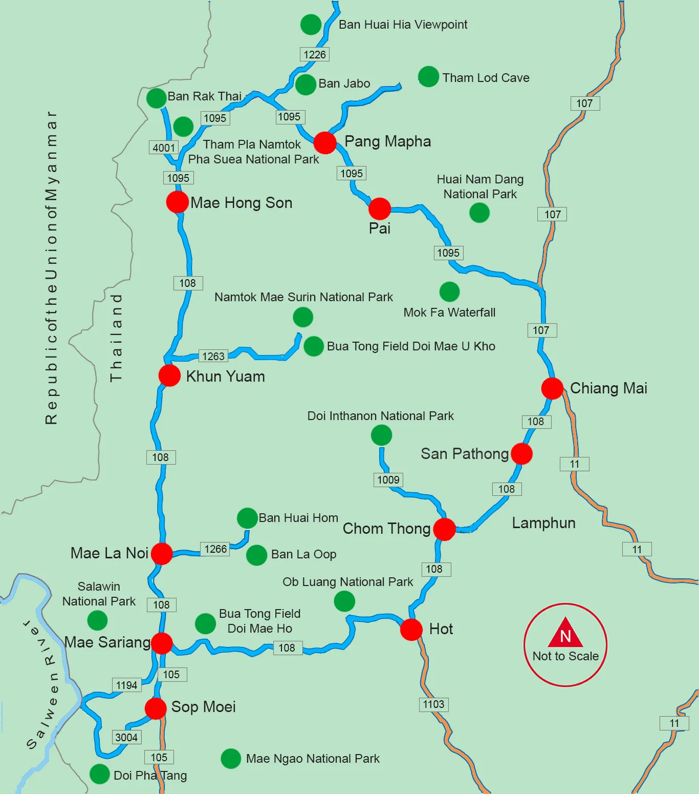
Mae Hong Son Loop Map