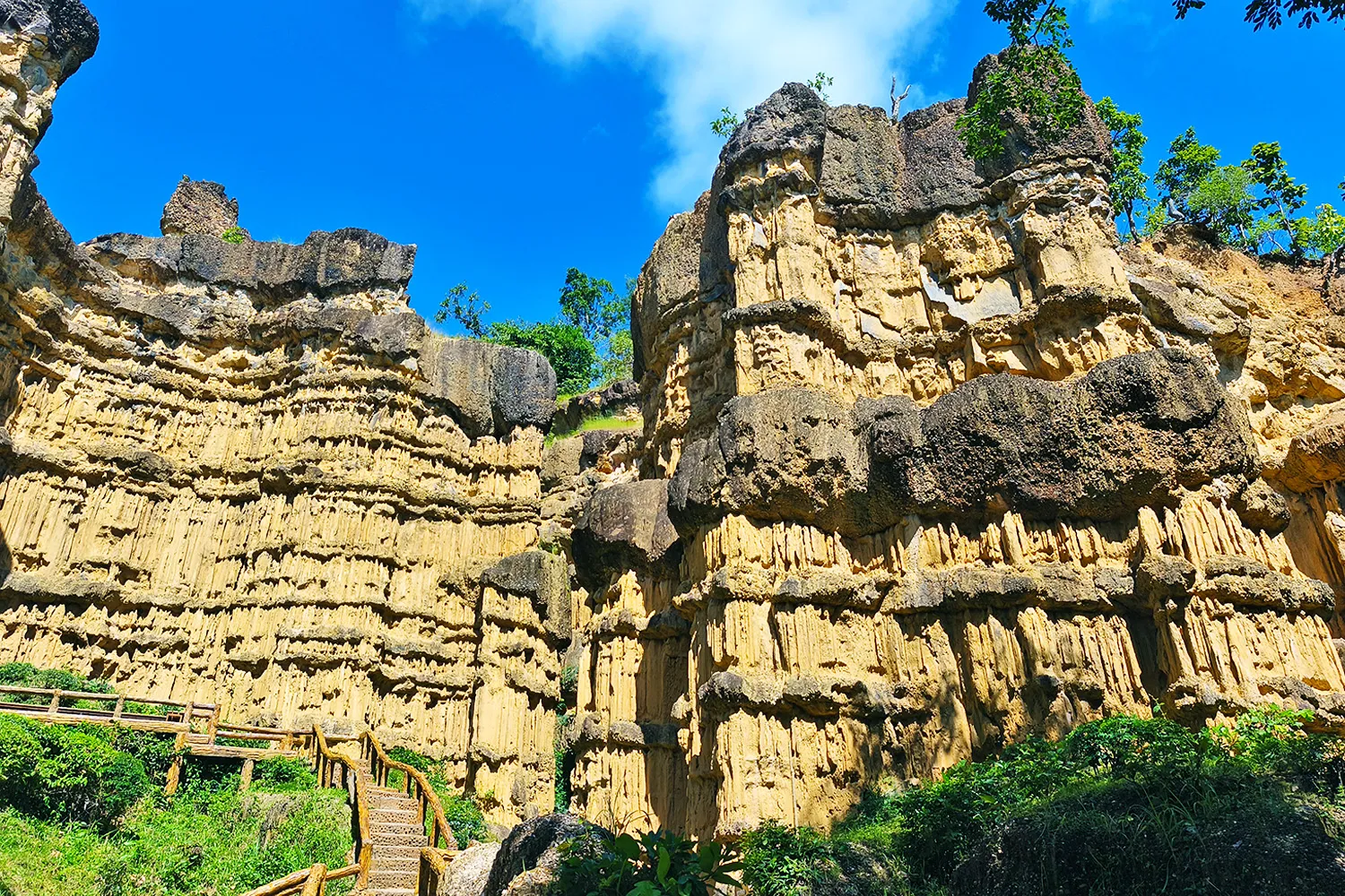
Pha Chor, situated within the scenic Mae Wang National Park in Santi Suk Sub-district, Doi Lo District, is undeniably one of Chiang Mai’s most captivating and awe-inspiring natural attractions. This remarkable geological wonder offers visitors the chance to step into a landscape shaped entirely by the patient hand of nature. Towering earthen cliffs, weathered pillars, and dramatic canyon-like walls rise impressively from the ground, creating a panorama that feels both surreal and majestic. Formed over millions of years through the processes of land subsidence, erosion, wind, and rainfall, the site is a living testament to the artistry of the natural world. Often hailed as the “Grand Canyon of Thailand” for its striking resemblance to the iconic landmark in the United States, Pha Chor has become a must-visit destination for travelers who seek both natural beauty and a sense of adventure. Its peculiar formations and towering monoliths never fail to spark awe and curiosity, making it a favorite among geologists, photographers, and nature enthusiasts alike. Beyond admiring the rock structures, visitors can also enjoy a series of walking trails that wind through the surrounding forest, offering peaceful moments amidst lush greenery and fresh mountain air. A journey to Pha Chor is more than just a sightseeing stop—it is an encounter with the Earth’s ancient past and a reminder of nature’s power to sculpt landscapes of extraordinary grandeur. Whether you are marveling at the towering walls, capturing the perfect photograph, or simply pausing to take in the serene environment, the experience leaves a lasting impression. For those exploring Chiang Mai’s diverse landscapes, Pha Chor stands out as a destination that beautifully blends natural wonder, geological significance, and tranquil adventure, ensuring every visitor departs with a deeper appreciation for Thailand’s breathtaking natural heritage.
Getting to Pha Chor:
Getting to Pha Chor is relatively straightforward, especially for those traveling by private vehicle. Mae Wang National Park, where Pha Chor is located, lies about 50 kilometers from Chiang Mai city and can be reached in roughly one and a half hours under normal driving conditions. The most convenient route begins in Chiang Mai city, heading south along Highway 108 (the Chiang Mai–Chom Thong Road). Travelers should follow the signs indicating Mae Wang National Park or Pha Chor, and upon reaching Doi Lo District, make a U-turn before turning left onto Rural Highway 3065, then continue onto Rural Highway 2069. The journey passes through a scenic countryside, and the roads are generally well-maintained with alternating stretches of asphalt and concrete, though certain segments can be narrow and winding, especially as you approach Pha Chor, so cautious driving is recommended. While Pha Chor can be visited at any time of the year, the most pleasant period is from November to February, when the weather is cool, skies are clear, and conditions are ideal for outdoor exploration and photography. Before setting out, visitors are encouraged to check the national park’s current regulations, as temporary closures may occur to allow the ecosystem to recover naturally. Entrance fees for foreign visitors apply, with rates of 100 baht for adults, 50 baht for children, 30 baht per car, and 20 baht per motorcycle.

Hiking Trails and Activities:
Hiking Trails and Activities at Pha Chor offer visitors an immersive way to experience the beauty of this remarkable geological site and its surrounding landscapes. There are two main hiking trails to choose from, each providing a different perspective and level of challenge. The first trail begins at the first parking lot, where visitors are immediately rewarded with a breathtaking panoramic view of the area before descending into the valley below. This path is relatively steep and winding, but it is equipped with well-maintained steps and railings to ensure safety as it meanders through the forest. Along the way, informative signs and interpretation boards highlight the unique geological formations and ecological features, making the walk both educational and scenic. At the base of the valley, the magnificent Pha Chor formation rises dramatically, offering a truly awe-inspiring sight. The round trip along this trail covers approximately 900 meters and generally takes about an hour to complete at a leisurely pace. The second trail, which begins at the third parking lot, is ideal for those who prefer a gentler route. This path follows a stream and is mostly flat with only a slight ascent before reaching Pha Chor. It is shaded by diverse vegetation and also features informative signage to enhance the experience. Exiting along this route requires passing through a fascinating narrow pathway known as “Hom Kong Keed,” where both sides are framed by striking mounds sculpted by water over countless years into unusual and picturesque shapes. To protect the delicate environment and ensure safety, visitors are kindly reminded to follow the park’s guidelines: refrain from climbing on cliffs or rock formations to prevent accidents or damage, avoid littering and carry out all trash, and do not hunt or collect plants or animals. Appropriate footwear is strongly recommended, as the trail includes steps and uneven terrain in some sections, and visitors should bring water, a hat, and sunscreen since the valley floor can become hot during the day. By following these guidelines, every traveler can enjoy a safe, respectful, and memorable journey through one of northern Thailand’s most extraordinary natural wonders.
Park Facilities:
The park offers a range of basic yet convenient facilities to ensure a comfortable experience for visitors. These include a tourist information center that provides guidance about the area, several well-maintained parking lots, and clean restrooms located at different points within the park. For refreshments, visitors can enjoy a small restaurant serving food and beverages, as well as local food stalls near the main entrance and parking areas that offer simple yet delicious Thai dishes, snacks, and drinks. For those who wish to extend their visit, the park also provides overnight accommodations and designated camping areas, allowing travelers to immerse themselves in the natural surroundings after sunset. To learn more about available services, regulations, or to plan an extended stay, visitors are encouraged to visit the official website of the Department of National Parks, Wildlife and Plant Conservation.
Pha Chor is not only a breathtaking geological wonder, but also a profound testament to nature’s artistry and resilience. Towering cliffs sculpted by centuries of erosion rise dramatically from the earth, forming a landscape that evokes both awe and serenity. Nestled within the peaceful terrain of Chiang Mai’s Mae Wang National Park, this natural marvel offers visitors a rare opportunity to immerse themselves in the quiet majesty of the outdoors. Whether you come seeking panoramic views, striking photographs, or a deeper understanding of Thailand’s geological history, Pha Chor extends a warm welcome to all. The fresh mountain air and tranquil surroundings invite reflection, while the sheer scale and beauty of the formations inspire wonder. A journey to Pha Chor is far more than a sightseeing excursion—it is a meaningful experience that fosters a deeper connection with the natural world and leaves a lasting impression on the heart. For travelers exploring Chiang Mai, a visit to Pha Chor is a memorable highlight that blends adventure, education, and emotional resonance. It’s a place where nature speaks in silence, and every moment spent is a gentle reminder of the earth’s enduring power and grace.
The Majestic Mountains of Chiang Mai
Nestled in the mountainous heart of Northern Thailand, Chiang Mai is home to some of the country’s most spectacular and ecologically diverse peaks. The province is widely celebrated not only for its rich Lanna culture and ancient temples, but also for its dramatic mountain landscapes that stretch across vast national parks, dense evergreen forests, rolling grasslands, and mist-covered ridges. These mountains shape the character of Chiang Mai, influencing its climate, biodiversity, local traditions, and way of life, while also making the province one of Thailand’s premier destinations for nature lovers and adventure travelers. Among the many mountains found throughout Chiang Mai are several of the highest peaks in Thailand. Doi Inthanon, the highest mountain in the country, rises majestically above layers of cloud forests and cool-weather landscapes rarely associated with tropical Southeast Asia. Nearby stands Doi Pha Hom Pok, the second-highest peak in Thailand, known for its untouched wilderness and breathtaking sunrise viewpoints. Another iconic mountain is Doi Luang Chiang Dao, the third-highest mountain in the nation, famous for its towering limestone cliffs and extraordinary natural beauty. Together, these mountains form part of a vast mountainous network that dominates much of Chiang Mai’s geography and gives the province its distinctive scenic identity. The mountains of Chiang Mai are covered with a remarkable variety of forests and ecosystems. Depending on elevation and climate, visitors can encounter tropical rainforests, pine forests, cloud forests, bamboo groves, and expansive highland grasslands. During the cool season, the mountain air becomes refreshingly crisp, creating an atmosphere very different from Thailand’s lowland regions. Morning mist drifting through valleys and across ridgelines often creates unforgettable panoramic views, especially during sunrise when golden light spreads across layers of mountains stretching toward the horizon.
These mountainous regions are also home to an incredible diversity of wildlife and plant species. Many areas are protected within national parks and wildlife sanctuaries, preserving rare flora and fauna found only in Thailand’s northern highlands. Birdwatchers from around the world visit Chiang Mai’s mountains to observe rare and migratory species, while botanists and nature enthusiasts are drawn to the region’s unique alpine vegetation and seasonal wildflowers. In some locations, flowering cherry blossoms bloom during the cooler months, adding unexpected shades of pink and white to the mountain scenery. Beyond their natural beauty, the mountains of Chiang Mai also hold deep cultural significance. Ethnic hill tribe communities such as the Karen, Hmong, Lahu, Lisu, and Akha have lived among these highlands for generations, maintaining traditions, languages, and lifestyles closely connected to the surrounding environment. Their villages, often located along mountain slopes or hidden within forest valleys, contribute to the cultural richness of the region and provide visitors with opportunities to experience local traditions and hospitality. For travelers seeking outdoor experiences, Chiang Mai’s mountains offer countless opportunities for trekking, camping, photography, and scenic exploration. Some peaks require demanding multi-day hikes, while others are relatively accessible and suitable even for casual travelers. The diversity of terrain means that each mountain possesses its own unique atmosphere — from rugged limestone cliffs and dense jungle trails to sweeping grass-covered ridges and tranquil forest viewpoints. Among the many peaks found throughout Chiang Mai, two mountains in particular stand out for their exceptional scenery and rewarding accessibility: Mon Jong and Doi Luang Chiang Dao. Both mountains are widely regarded as some of the most beautiful destinations in Northern Thailand, offering striking landscapes, memorable trekking experiences, and breathtaking natural surroundings without being overly difficult to reach. Their balance of accessibility and scenic grandeur has made them increasingly popular among both Thai and international travelers seeking authentic mountain experiences in Chiang Mai.
Doi Mon Chong:
Rising gracefully within the vast wilderness of Northern Thailand, Mon Chong is one of the most spectacular mountain destinations in Chiang Mai and a hidden paradise for trekking enthusiasts seeking untouched natural beauty. Located in Mae Tuen Subdistrict, Omkoi District, the mountain lies within the protected area of the Omkoi Wildlife Sanctuary and reaches an elevation of approximately 1,949 meters above sea level. Its landscape stretches across parts of Chiang Mai and neighboring Tak Province, forming an important ecological sanctuary that remains remarkably rich in biodiversity and pristine forest ecosystems. Unlike many crowded tourist destinations, Doi Mon Chong still preserves a strong sense of wilderness, where dense forests, rolling mountain ridges, and expansive grasslands create dramatic scenery unlike anywhere else in Thailand. The mountain is particularly famous for its vast golden fields of grass that transform during the cool season, covering the ridgelines in glowing shades of gold beneath the soft winter sunlight. This breathtaking landscape, combined with layers of distant mountains fading into the horizon, has made Doi Mon Chong one of the most admired trekking destinations in the country. Many hikers also consider it one of Thailand’s finest locations for both sunrise and sunset viewing, as early morning mist drifts slowly through the valleys while evening light paints the mountains in warm orange and crimson tones. Along the trekking route, visitors may also encounter rare wildlife and unique highland vegetation, including the beautiful Rhododendron flowers, locally known as “Kularb Phan Pee” or the thousand-year rose, which blooms from December to January and adds vibrant color to the mountain landscape during the cold season.
Trekking to the summit of Doi Mon Chong has become increasingly popular among adventurous travelers and nature lovers who wish to experience one of Thailand’s last truly unspoiled mountain environments. However, to preserve the fragile ecosystem and allow the forest to naturally recover, the mountain is open to visitors only from November until February 15 each year, after which the area is completely closed for conservation purposes. The trekking trail itself is approximately 6–7 kilometers long and usually takes around 3–4 hours to complete depending on physical condition and weather conditions. Although it is technically possible to visit as a day trip, most hikers prefer spending 2 days and 1 night on the mountain in order to fully appreciate the scenery without rushing. Overnight camping is permitted only in designated camping areas, where travelers can enjoy star-filled skies and the peaceful atmosphere of the highlands. There are two main trekking starting points available: Ban Musoe and Ban Pang Tueng. Before entering the area, all visitors must obtain permission from the Omkoi Wildlife Sanctuary, either directly at the sanctuary office or through the official online reservation system. Since facilities on the mountain are extremely limited, trekkers are required to prepare their own food, drinking water, tents, sleeping bags, and other trekking equipment. Temperatures on the summit can become very cold, especially during December and January, so warm clothing and proper cold-weather gear are highly recommended. Additional expenses for the journey may include four-wheel-drive transportation to and from the trekking trailhead, porter services, and local guides, all of which can be further inquired about at the wildlife sanctuary. Strict regulations are enforced to protect the environment, including mandatory local guides for all trekking groups, a strict no-littering policy, and prohibitions against disturbing wildlife, hunting, collecting forest products, or removing plants from the protected area. Visitors are expected to carefully follow all sanctuary regulations and complete all necessary payments and registration procedures before beginning the trek.
Reaching Doi Mon Chong is itself part of the adventure and offers travelers an opportunity to experience the remote beauty of Southern Chiang Mai’s mountainous countryside. By private car, travelers can depart from Chiang Mai city via Highway 108 toward Hot District before turning left onto Highway 1099 toward Omkoi District. From Omkoi town, visitors continue along Highway 1099 for approximately 40 kilometers until reaching the Musoe Unit of the Omkoi Wildlife Sanctuary, located on the left-hand side of the road. From the sanctuary office, the trekking starting point is still around 16 kilometers away along a rough mountain route that requires a four-wheel-drive vehicle and a highly experienced driver due to the steep, narrow, and winding dirt roads. Fortunately, local villagers operate four-wheel-drive transportation services for visitors at the Musoe Unit of the Omkoi Wildlife Sanctuary, providing a safer and more convenient way to access the trekking trail leading to Mon Chong. For those traveling by public transportation, buses to Omkoi depart daily from the Chang Phueak Bus Station in Chiang Mai city between approximately 8:00 AM and 1:00 PM. Because organizing permits, transportation, equipment, and local guides can sometimes be challenging for independent travelers, many visitors choose to join trekking tours operated by local tour companies based in Chiang Mai. These tour operators often provide complete trekking packages that include transportation, camping equipment, meals, and guide services, making the journey more convenient and accessible for travelers who wish to experience the extraordinary beauty of Doi Mon Chong without having to arrange every detail themselves.
Doi Luang Chiang Dao:
Towering dramatically above the northern mountains of Chiang Mai, Doi Luang Chiang Dao is widely regarded as one of the most breathtaking trekking destinations in Thailand. Located within the Chiang Dao Wildlife Sanctuary in Chiang Dao District, this magnificent limestone mountain rises to approximately 2,195 meters above sea level, making it the third-highest peak in the country after Doi Inthanon and Doi Pha Hom Pok. Unlike many other mountains in Thailand, Doi Luang Chiang Dao is characterized by its dramatic limestone cliffs, rugged ridgelines, and narrow summit plateau that offers spectacular 360-degree panoramic views across layers of endless mountain ranges. The mountain’s cool climate, strong winds, and extraordinary biodiversity create a unique highland environment filled with rare alpine flowers, colorful butterflies, and numerous bird species that thrive within the protected ecosystem. During the cool season, the atmosphere on the mountain becomes especially magical as morning mist flows slowly through the valleys below while the first sunlight illuminates the limestone peaks in soft golden colors. Because of its fragile ecosystem and ecological importance, Doi Luang Chiang Dao is managed under strict conservation regulations with a limited number of visitors allowed each day, generally no more than 100–150 people. This controlled tourism system has helped preserve the mountain’s pristine natural beauty, peaceful atmosphere, and unspoiled wilderness, making it one of the few places in Thailand where travelers can still experience nature in its purest form. The mountain is open for trekking and overnight camping only from mid-November until mid-February each year, when weather conditions are safest and most suitable for visitors.
Trekking to the summit of Doi Luang Chiang Dao is considered one of the most rewarding hiking experiences in Northern Thailand and is typically recommended as a 2-day, 1-night journey. However, unlike some trekking destinations that allow walk-in visitors, access to the mountain is strictly by advance reservation only. Travelers must first register through the official website of the Chiang Dao Wildlife Sanctuary by selecting the nature study trail reservation system and choosing an available trekking date. Visitors are required to provide accurate personal information including full name, passport number, telephone number, and the actual number of travelers in the group, as these details are carefully verified upon arrival. After selecting the available trekking route for the season and specifying the number of nights for camping, the system automatically calculates the required fees before payment is completed through the designated channels. Visitors must keep all payment confirmations and reservation documents, as these are necessary when checking in at the wildlife sanctuary office. Upon arrival, trekkers are required to present their booking confirmation, original passport, and a medical certificate issued no more than seven days before the trip. In addition, all visitors must report to the sanctuary office at least one day before the trek begins in order to attend a mandatory orientation covering safety procedures, environmental regulations, and trekking guidelines. Failure to report within the specified timeframe may result in cancellation of trekking permission. Strict environmental rules are enforced throughout the trek to protect wildlife and maintain the peaceful atmosphere of the sanctuary. Loud noises and alcoholic beverages are strictly prohibited, campfires and strong-smelling cooking are not allowed, and all garbage must be carried back down from the mountain. Trekkers must remain with their group and local guide at all times while staying on designated trails to minimize environmental impact.
Traveling to Doi Luang Chiang Dao from Chiang Mai city is relatively convenient compared to many other remote trekking destinations in Northern Thailand. The journey by private car or hired vehicle takes approximately 1.5 to 2 hours via well-paved roads leading directly to the Chiang Dao Wildlife Sanctuary office, making the route accessible for nearly all types of vehicles. There are generally two main trekking routes available depending on seasonal conditions and conservation management. The most popular and frequently opened route is the Den Ya Khat trail, a longer but more gradual ascent that passes through a fascinating variety of landscapes including dense evergreen forest, pine forest, open grasslands, and exposed ridgelines with magnificent panoramic views. This route is often recommended for beginner to intermediate trekkers due to its balanced difficulty level and scenic diversity. The second route, known as Pang Wua, is shorter in distance but considerably steeper and more physically demanding in certain sections, making it better suited for experienced trekkers seeking a greater challenge and a deeper wilderness experience. Along this quieter route, hikers can enjoy a more secluded atmosphere surrounded by dense forest and untouched mountain scenery. In addition to transportation costs, trekking expenses usually include entrance fees, porter services, and mandatory local guides, all of which can be further inquired about at the Chiang Dao Wildlife Sanctuary. Since facilities on the mountain are extremely limited, visitors must prepare their own food, drinking water, tents, sleeping bags, and trekking equipment. However, for travelers who prefer a more comfortable and organized experience, several tour operators based in Chiang Mai offer complete trekking packages to Doi Luang Chiang Dao, including transportation, camping equipment, meals, permits, and guide services, allowing visitors to fully enjoy one of Thailand’s most extraordinary mountain adventures without having to arrange every detail independently.
Northern Thailand / Mae Hong Son / Chiang Mai / Chiang Mai Temples / Chiang Mai Festivals / Chiang Mai Activities / Chiang Mai Night Markets / Northern Thai Foods / Doi Inthanon National Park / Buddha Image in Thailand / Murals in Northern Temples / Wiang Kum Kam Ancient City / Arts and Beliefs in Northern Temples / Pha Chor Thailand Grand Canyon